Zeacliff, Zealand Pond, Zealand Falls
| Destinations: | Zeacliff Outlook (3700'), Zealand Pond (2457'), Zealand Falls, Zealand Falls Hut (2630'), Whitewall Brook Outlook (2630') | |
| Trails: | Zealand Trail, Twinway, Appalachian Trail | |
| Region: | NH - Central East White Mountain National Forest, Little River Mountains | |
| Location: | Bethlehem, NH | |
| Rating: | Moderate | |
| Features: | Ponds, views, hut, wetlands, river, brook, waterfall, cascades | |
| Distance: | 7.8 miles | |
| Elevation Gain: | 1700 feet (cumulative) | |
| Hiking Time: | Typical: 4:45 | |
| Outing Duration: | Typical: 7:00 | |
| Season: | Spring | |
| Hike Date: | 06/14/2008 (Saturday) | |
| Last Updated: | 11/05/2009 | |
| Author: | Mark Malnati | |
| Companions: | Twelve SDHers, 2 dogs |
 Route Summary
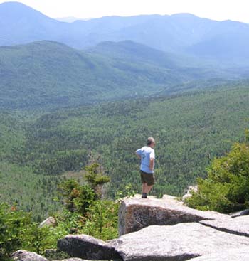
This hike follows Zealand Trail to Zealand Pond and then continues up via Twinway past Zealand Falls, Zealand Falls Hut, and finally to the Zeacliff outlook. Zeacliff offers magnificent views of Zealand Notch and the eastern part of the Pemigewasset Wilderness.
- Start at the end of Zealand Road and head up Zealand Trail for 2.5 miles until reaching the end of the trail at Zealand Pond.
- After hiking up the gentle Zealand Trail for 0.8 mile, you will reach Zealand River where the trail curves to the right and a short spur path leads left to the shoreline of the river.
- A mile farther along Zealand Trail will bring you to a pretty wetlands area crossed by a sturdy boardwalk.
- A half-mile after that A-Z Trail goes off to the left; continue straight on Zealand Trail.
- Just 0.2 mile more of easy walking and you will arrive at Zealand Pond on the right where a few strides off the trail will bring you to the shoreline of the pond at a small opening in the trees.
- Just beyond this point, Zealand Trail ends as it meets Ethan Pond Trail and Twinway. Twinway is part of the Appalachian Trail.
- At the junction of Zealand Trail, Ethan Pond Trail, and Twinway/Appalachian Trail, bear right to follow Twinway/Appalachian Trail while Ethan Pond Trail veers off to the left. At this point you are only 0.2 mile away from Zealand Falls Hut. Between here and the hut are two access points to Zealand Falls.
- The first access spot to the falls is where the main trail veers right and there is an obvious path to the left. Follow the side trail for about 40 feet and you'll be at the tail end of Zealand Falls where there is a series of small cascades.
- Returning to the main path, the trail climbs steeply up toward the hut via stone steps. About halfway up this pitch, is another spur leading to the left, only about 20 feet long, and it brings you to the main section of Zealand Falls where the water drops straight down a 15-foot high cliff. If you're feeling a bit adventurous, you can work your way down the embankment and then across the stream to the ledgy area directly at the foot of the falls.
- Back on the main trail, tackle the final portion of the steep climb to arrive at Zealand Falls Hut. Here you may want to make a quick detour, just beyond the hut, to the left of the main trail to Whitewall Brook which slides across slanted open ledges before dropping sharply below. There are good views from these ledges.
- Beyond the hut, continue on Twinway/Appalachian Trail and after barely 0.1 mile you will arrive at a junction with Lend-A-Hand Trail. Turn left to keep following Twinway/Appalachian Trail while Lend-A-Hand Trail goes straight/right.
- Follow Twinway/Appalachian Trail for an additional 1.1 miles then keep going straight, leaving the official Twinway/Appalachian Trail route which turns right. After about 50 yards you will reach the Zeacliff outlook. This spur trail rejoins the main path just a short ways past the outlook.
- After enjoying the views, retrace your steps to return to the parking lot.

| Place | Split Miles |
Total Miles |
||
|---|---|---|---|---|
| Zealand Trail parking area (2000') | 0.0 | 0.0 | ||
| Zealand River (2200') | 0.8 | 0.8 | ||
| Beaver swamp zigzag bridge (2400') | 1.0 | 1.8 | ||
| Jct. Zealand Trail / A-Z Trail (2450') | 0.5 | 2.3 | ||
| Zealand Pond and Jct. Ethan Pond Trail / Twinway / Zealand Trail (2460') | 0.2 | 2.5 | ||
| Zealand Falls | 0.1 | 2.6 | ||
| Zealand Falls Hut (2630') | 0.1 | 2.7 | ||
| Zeacliff outlook (3700') | 1.2 | 3.9 | ||
| Zealand Falls Hut (2630') | 1.2 | 5.1 | ||
| Zealand Pond and Jct. Ethan Pond Trail / Twinway / Zealand Trail (2460') | 0.2 | 5.3 | ||
| Jct. Zealand Trail / A-Z Trail (2450') | 0.2 | 5.5 | ||
| Beaver swamp zigzag bridge (2400') | 0.5 | 6.0 | ||
| Zealand River (2200') | 1.0 | 7.0 | ||
| Zealand Trail parking area (2000') | 0.8 | 7.8 |
|
|
|||||
|
|
|||||
|
|
|||||
Trail Guide
On a nice warm Saturday, twelve hikers and two dogs hiked up the Zealand Trail. We took a break at the hut.
While two hikers stayed at Zealand Falls to play in the water the rest of us continued to the top of Zeacliff to enjoy the views. The views from Zeacliff were fantastic, the cliffs of Whitewall Mountain were beautiful and we could see the Ethan Pond Trail cut across the slides. We had lunch at the top and then descended back down to the falls.


Once we were back at the falls, shoes and socks came off and we cooled our feet in the water. It is not clear who instigated it, but Dennis and Soleil got into a water fight that somehow managed to get a couple of others wet. Nobody was complaining, the water felt great.
No one wanted to move after our break at the falls, but eventually we headed down the rest of the trail to the parking lot. Part of the group wanted the traditional post-hike ice cream, but there was some heavy lobbying for nachos and buffalo wings. In the spirit of trying to keep everyone happy we did both!
Special thanks to Deb for being so helpful.
|
|
|||||
|
|||||


The Zealand Trailhead is located in Bethlehem, New Hampshire at the end of Zealand Road which can be found on the south side of Rt. 302.
From the East:
- Traveling on Rt. 302 West, Zealand Road is about 9.2 miles west of the Willey House Historical Site, and about 6.5 miles west of the AMC Highland Center. Zealand Road as well as both of these landmarks are all on the left-hand side of the road.
- Turn left onto Zealand Road.
- 3.5 miles from Rt. 302, Zealand Road ends and there is a large parking area on the left.
- The trailhead is straight-ahead from the road.
From the West:
- From the junction of Routes 302 and 3 in Carroll (Twin Mountain), go east on Route 302.
- After 2.1 miles, turn right onto Zealand Road.
- 3.5 miles from Rt. 302, Zealand Road ends and there is a large parking area on the left.
- The trailhead is straight-ahead from the road.
Winter: Zealand Road is closed to vehicular travel during the winter, although hikers and skiers are welcome to use it. Snowmobile trails also intersect the road in a couple spots. There is a large winter parking lot on Route 302, 0.2 mile east of Zealand Road. Parking here instead of at the far end of Zealand Road adds 3.7 miles (each way) and 500 feet of elevation gain to the hike.
Check out the White Mountain National Forest's road status page for the most up-to-date information on road closures.
Facilities
Bathrooms in parking area. Zealand Falls Hut with bathrooms and kitchen and lodging facilities.


WMNF Recreational Pass
A parking permit is required to park at White Mountain National Forest trailheads and parking areas. You can purchase a WMNF permit from the forest service and other vendors and can also pay-by-the-day using self-service kiosks located in many parking areas.
For more information on parking passes please refer to the White Mountain National Forest website.
Rates:
- $5 per day
- $30 for a year-long pass
- $40 for a year for a household
More Zealand Pond, Zealand Falls, Zeacliff Trail Reports
- Ethan Pond, Thoreau Falls, Zealand Notch, Zealand Falls, Zealand Pond on 6/06/2009
- Zealand Mtn, Mt. Guyot, and the Bonds 2-day backpack on 8/14/2009
- Zealand Pond, Zealand Falls, Zealand Falls Hut 2-day backpack on 1/31/2009
- Mt. Hale, Zealand Falls, Zealand Pond on 5/10/2008
- Zealand Pond, Zealand Falls, Mt. Hale on 8/17/2007
- Cannon, Lafayette, Garfield, South Twin, Guyot, Zeacliff 5-day backpack on 6/20/2006


Website by
![]() LeapfrogProgramming.com
LeapfrogProgramming.com
© 1998-2025
![]()
| The information on this site may freely be used for personal purposes but may not be replicated on other websites or publications. If you want to reference some content on this site, please link to us. |


