|
|
|||||
| Destination: | Lime Rock Preserve Pond | |
| Trails: | Rail Trail, Pond Loop | |
| Region: | RI - Northern Lime Rock Preserve | |
| Location: | Lincoln, RI | |
| Rating: | Easy | |
| Features: | Pond, rare plant species | |
| Distance: | 2.0 miles | |
| Elevation Gain: | Minimal | |
| Hiking Time: | Actual: 1:30 Typical: 1:00 | |
| Outing Duration: | Typical: 2:00 | |
| Season: | Summer | |
| Hike Date: | 09/06/2007 (Thursday) | |
| Last Updated: | 01/22/2008 | |
| Weather: | 75 degrees; persistent, welcome breeze | |
| Author: | Webmaster |
Route Summary
This hike to Lime Rock Preserve Pond starts on an old railway bed, and then follows a combination of foot paths and woods roads to loop around the pond and return to the railway bed.
- Follow the old railroad bed for almost a half-mile until you see a path leaving it on the right.
- Take that right-hand turn and follow the footway as it skirts around the pond.
- Keep following the trail that most closely follows the pond's perimeter (there are several trails shooting off in other directions).
- When you reach a T-junction, you are back at the railroad bed (but farther along from where you left it).
- Turn left and follow the railroad bed back to the parking area.
| Place | Split Time |
Total Time |
|||
|---|---|---|---|---|---|
| Trailhead on Wilbur Road | 0:00 | 0:00 | |||
| Jct. Rail Trail/Pond Loop | 0:25 | 0:25 | |||
| Pond dam | 0:10 | 0:35 | |||
| Fork Pond Loop/Dirt Road | 0:10 | 0:45 | |||
| T-jct. Pond Loop/Rail Trail | 0:10 | 0:55 | |||
| Trailhead on Wilbur Road | 0:35 | 1:30 |
|
|
|||||


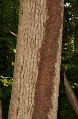
 Lime Rock Preserve captivated me right from the beginning. At the trailhead, I immediately noticed some strange and interesting vines. One was a thick vine, running straight up a tree. The vine was about 3 inches wide and 1 inch high and appeared to be covered with unruly hair made of something resembling dried pine needles. It was a little bit creepy looking and I half-expected it to start writhing along like a snake and come and get me!
The other interesting vine at the trailhead, I have nicknamed the "strangler vine". This plant was all woody, looking more like a twisted tree trunk rather than any type of leafy green vine that I'm accustomed to. It had wrapped itself around a rather small tree, spiraling upwards. Then it must have decided that it liked a neighboring tree better and so leaned its host tree over to the new tree and wrapped around both the trees... and apparently eventually caused the original tree to snap apart horizontally. This strangler was about 2 inches thick; it wasn't as creepy-looking as the first vine but perhaps it's more ruthless.
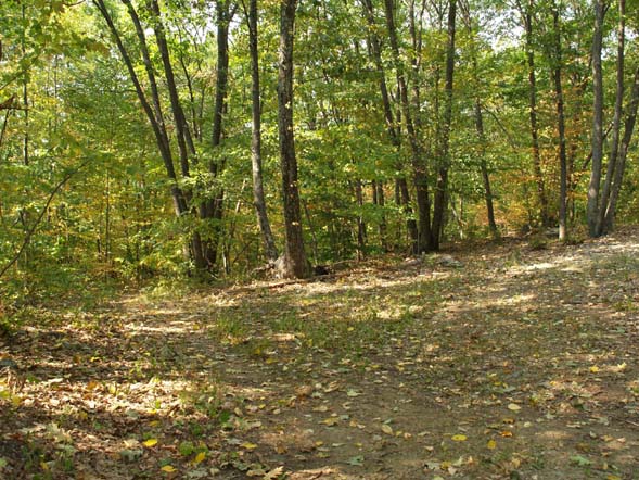
And now on to the trail. Neither the trails nor the pond have any names so I have dubbed the former electric railroad bed the "Rail Trail" and the portion of the trail that veers off and circles the pond the "Pond Loop". And I'm calling the pond, the "Lime Rock Preserve Pond". Not very original but it's easier to discuss the different trails when they have names.
The Rail Trail is very straight and soon you will see a smaller path leaving the main rail bed to the left. This path closely parallels the railroad bed, never getting more than a dozen feet away. During spring or after rains the main trail can be wet or muddy so the smaller footpath provides an alternative "higher ground" (only a few feet higher) route.
The rail trail was mostly nice and smooth but there were rougher, rockier sections. The woods were predominately tall beech and oak but also had maple and other types of trees. There were some interesting looking boulders visible from the path and also some small ledgy areas along the trail.
 A high level of limestone in the preserve's soil is credited with providing a rich habitat encouraging the growth of many interesting plants. Since I was walking in September, I didn't see much in bloom, but I did see abundant Jack-in-the-pulpit plants in fruit. In most cases there was just a thick stalk topped by a dense cluster of bright red berries; but in a couple places I was able to spot the leaves of the plant that normally overtop the flower or fruit cluster.
I saw some Christmas ferns with their thick, waxy, rather plain (but pretty) evergreen fronds. And then there were some sensitive ferns that had beady fertile fronds in addition to their more common non-fertile foliage. The sensitive fern can be easily identified because it's not very lacey or "ferny" looking. Its fronds die back each season so they are not thick or waxy. This fern gets its common name because its leafy fronds will die with the first frost. However its narrow, beady fertile fronds will persist through the winter.
I also came across some wilted false Solomon's seal in fruit with loose clusters of red, or red-speckled opaque berries. I saw some white wood asters in bloom and many green plants that I unfortunately am not familiar with. The month of May would be a great time to revisit this preserve with field guide in hand. A strange animal call turned out to be simply two trees rubbing together producing an eerie sound.
There were large clumps of smartweed in bloom, with deep green narrow leaves and spikes of tiny pink flowers. It was either long-bristled smartweed or Lady's thumb (another type of smartweed). It more closely matched the attributes of long-bristled smartweed but seemed to have the "splotches" on the leaves that are characteristic of Lady's thumb. Perhaps both species were mixed in together or maybe I was seeing a hybrid of the two.
I also saw white baneberry in fruit. Because its berries are white with a single black dot on them, these plants have earned the appellation of "doll's eyes". The berries protrude off of thick pinky-reddish colored stalks that make this plant quite striking even without flowers; in fact its small white blooms are rather drab in comparison.
Soon I arrived at a path leaving to the right; this is one end of the Pond Loop. I turned right to follow the narrower footpath that had a stone wall running a bit to its right side. The trail climbed up a small hill and from its apex I could spy the pond through the trees. I descended back down the hill, up the next hill, and finally down to the shore of the pond.

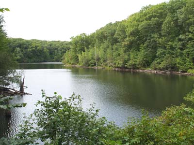
Veering to the left, I reached the earthen dam that crosses the pond. From here there was a pretty view of the pond. The pond was a somewhat elongated channel that curved off to the right out of sight. Looking directly across the pond I could see some small ledges with several old tree stubs poking out of the water.
The dam was in full sunlight so a profusion of wildflowers and shrubs populated the terrain with a tall white ash tree overlooking the pond's shore. Alder shrubs and sumac were present and also a shrub with abundant yellow berries. These berries each had a small single yellow spike sticking out from one end.
 There was quite a bit of goldenrod in bloom. Some dried mullein plants supported a leafy, "normal" vine that twined around the old flower stalk before curving away to join the mass of shrubs covering the embankment. There was also some dried thistle. And three different types of dragonflies were flitting around the area (brown, blue, and red in color).
Beyond the dam, the main route that I followed turned left and ascended a small hill. To the right was rocky, ledgy ground rising up above the trail and sassafras trees grew close to the path. Shortly after the top of the hill, the wide trail diverged right and a smaller footpath went left. I bore left to follow the route closer to the pond. Here there were a few small (about 6 feet high) white pines which was strange to see in woods supporting so many hardwood trees.
There were some interesting boulders to the left of the trail... perhaps some of these were the marble that is said to exist on the preserve. Soon I crossed a dry streambed on a ledgy bridge. Just upstream from this spot is where marsh marigolds grow in the spring. This species produces buttercup-bright yellow flowers and like very wet areas.
The Pond Loop traversed a few gentle inclines, all the while keeping the pond in sight through the trees. When you reach a T-junction, you have met up with the Rail Trail. At this point turn left and you will eventually reach the trailhead.
 This section of the Rail Trail is on higher ground and starts out by passing through a neat section with mini cliffs on either side of the trail. Then the landscape changes and instead there are deep ravines on both sides of the trail. A condo development can be glimpsed through the trees up to the right. In spite of the buildings as well as occasional road noise, this trail had a very peaceful, secluded ambiance.
The pond is visible from this section of the Rail Trail and at one point (when you've reached the part of the pond that you could see when looking straight across from the dam) there are two trails that descend sharply down to the pond's edge. The trails were sandy and the footing looked very poor so I chose to just observe the pond from the heights.
I next encountered the first leg of the Pond Loop trail (now on the left). I continued straight ahead to retrace my steps on the Rail Trail back to the parking area.
|
|
|||||


|
|||||


Lime Rock Preserve is located in Lincoln on Wilbur Road.
From Route 146 northbound:
- Take the exit for Rt. 123 west.
- Go to the traffic lights and then turn right onto Rt. 246 (a.k.a. Old Louisquisset Pike).
- After 1.7 miles from the lights, turn left onto Wilbur Road. This turn will be just after the Blackstone Valley Historical Society which is on the right.
- Follow Wilbur Road for 0.5 mile, then park on the right in a small dirt turnout.
From Route 146 southbound:
- Take the exit for Rt. 246.
- At the T-intersection, turn right onto Rt. 246 (a.k.a. Old Louisquisset Pike).
- After 0.3 mile, turn left onto Wilbur Road. This turn will be just after the Blackstone Valley Historical Society which is on the right.
- Follow Wilbur Road for 0.5 mile, then park on the right in a small dirt turnout.
The obvious trail leaves from the parking area. There are a couple informational signs about the preserve set back from the road as well as a short section of railed fence.

About Lime Rock Preserve
 Located in Lincoln, RI, The Nature Conservancy's Lime Rock Preserve consists of 130 acres. Ledges of dolomitic marble produce a special calcareous soil that nurtures 30 rare plant species - more than any other site in Rhode Island. May is a good time to see many of the flowers in bloom.
The main trail running along the western edge of the preserve is a rail bed from an abandoned electric train that used to run between Providence and Woonsocket. This trail as well as a loop trail provide views to the preserve's pond which serves as the town's reservoir.
The various habitats of this property include woodlands, forested swamps, streams, open water, and calcareous ledges. Winter provides a great opportunity to observe animal tracks.
The Lime Rock Preserve's name conjures up times past when limestone mining was an integral activity in this area - and in fact still continues today.
Before being replaced by cement over a hundred years ago, limestone was important to building because it made strong plasters and mortars. During the 1600 and 1700's, it was used to hold together "stone-enders"–an entire wall or massive chimney made of fieldstone constructed on the ends of otherwise wooden clapboard houses.
Lime is still heavily utilized today, not in construction, but to neutralize New England's acidic soils.

Preserve Visitation Guidelines
 The Nature Conservancy hopes that you enjoy visiting their preserves in any season and asks that you please observe the following guidelines:
- Stay on the walking trails, using marked trails wherever they exist.
- Some trails get wet and muddy. Please stay on the trails to avoid trampling plants and brushing against poison ivy.
- Respect preserve open hours (one hour before sunrise to one hour after sunset). Overnight camping is not allowed.
- Do not ride horses, bikes or any motorized vehicle through preserves or on the trails.
- No hunting.
- Leave your pets at home, for the safety of the fragile ecology of preserves and as a courtesy to other visitors.
- Do not remove any living materials from a preserve or disturb any vegetation.
- Remove any trash you create and, if possible, any garbage that you see left by someone else.
- Be careful! Your safety is your responsibility.


|
|
|||||


Website by
![]() LeapfrogProgramming.com
LeapfrogProgramming.com
© 1998-2024
![]()
| The information on this site may freely be used for personal purposes but may not be replicated on other websites or publications. If you want to reference some content on this site, please link to us. |

