Killington Peak via Bucklin Trail
| Mountain: | Killington Peak (4241') | |
| Trails: | Bucklin Trail, Long Trail, Appalachian Trail, Killington Spur | |
| Region: | VT - Southern | |
| Location: | Mendon, VT | |
| Rating: | Moderate/Difficult | |
| Features: | Summit, views, 4000-footer, lodge/restaurant, fire tower, brook | |
| Distance: | 7.2 miles | |
| Elevation Gain: | 2500 feet (cumulative) | |
| Hiking Time: | Typical: 4:55 | |
| Outing Duration: | Typical: 7:00 | |
| Season: | Summer | |
| Hike Date: | 08/25/2007 (Saturday) | |
| Last Updated: | 10/16/2008 | |
| Weather: | Humid, hazy | |
| Author: | Diane King | |
| Companion: | Five SDHers |
Route Summary
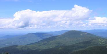
 This is a hike up to Killington Peak where there are far-reaching panoramic views to the Green Mountains of Vermont, the Adirondacks of New York, and the White Mountains of New Hampshire.
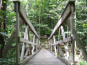
- Start on the blue-blazed Bucklin Trail and follow it for 3.3 miles all the way to the junction with the Long Trail and the Appalachian Trail. You will cross Brewers Brook on bridges after 0.2 mile and again at 1.2 miles into the hike. Bucklin Trail closely parallels Brewers Brook for about the first 1.4 miles of the hike. The first two miles climb gently and then the ascent becomes quite steep.
- Upon reaching the Long Trail and the Appalachian Trail (they run together at this point), turn right and follow the white-blazed LT/AT for just 0.1 mile.
- Next, turn left onto Killington Spur which will lead you to the summit after a 0.2-mile pitch straight to the top with some scrambling up large rocks to the open, rocky peak.
- Descend via the same route.
| Place | Split Miles |
Total Miles |
|||
|---|---|---|---|---|---|
| Bucklin Trailhead (1800') | 0.0 | 0.0 | |||
| Killington Peak (4241') | 3.6 | 3.6 | |||
| Bucklin Trailhead (1800') | 3.6 | 7.2 |
|
|
|||||

|
|
|||||


Trail Guide
 This hike was repeated on August 9, 2008 by six Seacoast Dayhikers. Although the trails were muddier than last time due to the abundant rain received this summer, the day itself was clear, rewarding the determined hikers with impressive views. Photos from both outings illustrate this report.
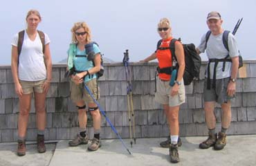
Five Seacoast Dayhikers ventured into the Green Mountain State for a hike up Killington - the second highest peak in Vermont. Clouds loomed over us at the parking lot on a humid summer morning. As we waited a bit for any last minute arrivals, Pat broke out an assortment of cupcakes in honor of Mark's birthday.
We started out on the easy path through the forest crossing Catamount Cross Country ski trail past a stream and wildflowers. The humidity made the steeper part of the climb more difficult as the sky brightened then faded repeatedly.
We inspected Cooper Lodge and journeyed up a 0.2-mile rugged pitch to the top. Once there, we swirled in a curtain of clouds hiding our promised reward. We scooted over to check out the Peak Restaurant instead of the missing view. Pat broke out the cupcakes again and we tested out the latest gadgets Jim had brought until bright sky became apparent.
We went out to the deck and looked upon the peaceful yet bustling view. We observed Pico Peak, Blue Ridge Mountain Peak, gondolas running up and down the lift station and brave mountain bikers taking various hard-packed and grassy trails down the mountain. Some of the more ventursome vowed to come back and do those trails on bike! Jim inquired for us as to the rates: $10 for one trip and $42 for as many trips as you can endure.


The restaurant had a mural depicting the famous "Long Trail Brewery" in downtown Killington and we decided we would need to inspect the brewery to see if this representation was accurate. We headed back down Bucklin Trail and met up with a couple of backpacking groups and a weary AT thru-hiker as well as a hiking spa group called New Life Spa. Jim inquired (again) of the rate: $249/day for hiking, food, aerobics and yoga and the experience of meeting people from around the country, like New York and Texas, and even one from France. The group had already hiked over to Blue Ridge Mountain that morning so I am guessing they got their money's worth.
At the Long Trail Brewery we replenished lost fluid, shopped, and sat on the deck sipping and munching on popcorn with a view of a stream and the welcome cooling as the clouds returned.


I am guessing everyone liked the hike as, throughout the day, people came up with excuses to return to Killington "when it is clearer for an even better view", "need to mountain bike", "need to return to the brewery when Arianna is of age"... and besides that we all have to find out the secret encrypted message of the Chinese tattoo she has. She was told it means "HOPE" and I explained how I heard in a documentary program that sometimes they tell you it means one thing when in reality it can mean pretty much anything. Her mom is convinced it means "Your Mother is a Pig" (the rest of us didn't think so). Anyway, Mark has homework as he photographed the artwork and will see to it that this gets properly translated. The rest of us hope for "HOPE". [And as a footnote, Mark did in fact confirm that it means "hope".]
Note: On a clear day, the vistas normally visible include the Green Mountains from Glastenbury Mountain to Mount Mansfield (Vermont's highest summit at 4,393 feet), Mount Ascutney (to the south), the White Mountains of New Hampshire (to the northeast), and (to the west) the Taconics, Lake Champlain, and the Adirondacks.
|
|
|||||


 The Bucklin Trailhead is located in Mendon, Vermont, not far from Route 4.
From Rt. 4:
- Turn south onto Wheelerville Road off of Rt. 4 in Mendon, Vermont. This turnoff can be found 5.1 miles east of the northern junction of Rt. 4 and Rt. 7 in Rutland; or 4.1 miles west of the Inn at Long Trail in Sherburn Pass.
- Follow Wheelerville Road for 4.1 miles.
- Park at the turnout on the left at Brewers Corner, located on a sharp corner of Wheelerville Road.
Facilities
Cooper Lodge, located 100 feet from the junction of the Long Trail/Appalachian Trail and the Killington Spur, is a bunk house for campers. At 3,850 feet, the lodge is the highest shelter on the Long Trail.
Shortly downhill from Killington Peak are facilities associated with the resort. The ski lodge at the summit has restrooms and a cafe with light food and beverage.
More Killington Peak Trail Reports
|
|
|||||

Website by
![]() LeapfrogProgramming.com
LeapfrogProgramming.com
© 1998-2025
![]()
| The information on this site may freely be used for personal purposes but may not be replicated on other websites or publications. If you want to reference some content on this site, please link to us. |