|
|
|||||
Fletcher's Cascade via Fletcher's Cascade Trail
| Destination: | Fletcher's Cascade (2200') | |
| Trails: | Drakes Brook Trail, Fletcher's Cascade Trail | |
| Region: | NH - Central East White Mountain National Forest, Waterville Valley | |
| Location: | Waterville Valley, NH | |
| Rating: | Moderate | |
| Features: | Cascades, brook | |
| Distance: | 3.2 miles | |
| Elevation Gain: | 800 feet (cumulative) | |
| Hiking Time: | Typical: 2:00 | |
| Outing Duration: | Typical: 3:00 | |
| Season: | Summer | |
| Hike Date: | 08/05/2000 | |
| Last Updated: | 01/20/2008 | |
| Weather: | About 65-70 degrees | |
| Author: | Webmaster | |
| Companions: | SDHrs: Marina, Ray W, Karen M, Sandy M, Dennis M, Genie, Elaine, Linda S, Sal S, Dave S, Marj W, Phil B, Pam S, Anne and Tom H, Mary, Linda B, Bob S, Kathy L, +6 others |
Route Summary
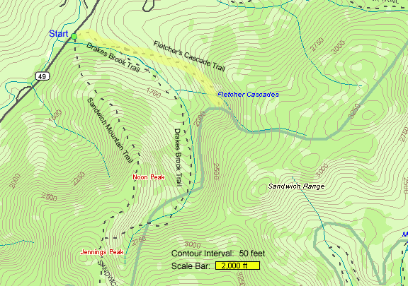
- Start on Drakes Brook Trail and follow that for 0.4 mile.
- Upon reaching a fork, bear left to follow Fletcher's Cascade Trail.
- After 100 yards, bear right at a fork and take Fletcher's Cascade Trail all the way up to the top of the cascades (1.2 miles on this trail).
- Return via the same route.
| Place | Split Miles |
Total Miles |
||
|---|---|---|---|---|
| Drakes Brook Trailhead (1400') | 0.0 | 0.0 | ||
| Jct. Drakes Brook Trail/Fletcher's Cascade Trail (1540') | 0.4 | 0.4 | ||
| Fletcher's Cascade (bottom) | 1.1 | 1.5 | ||
| Fletcher's Cascade (top) (2200') | 0.1 | 1.6 | ||
| Fletcher's Cascade (bottom) | 0.1 | 1.7 | ||
| Jct. Drakes Brook Trail/Fletcher's Cascade Trail (1540') | 1.1 | 2.8 | ||
| Drakes Brook Trailhead (1400') | 0.4 | 3.2 |
|
|
|
|||||

Trail Guide
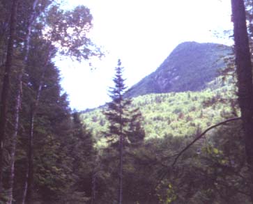
 Twenty-five SDHrs participated in this fairly easy walk up to Fletcher's Cascades. It was a pleasant
hike with the babbling Drakes Brook nearby for much of the way. Early on, there was an opening in
the woods which afforded a view of nearby Noon Peak. This 2976-foot mountain rises
dramatically above the trees, indulging us with an unexpected scenic treat.
Twenty-five SDHrs participated in this fairly easy walk up to Fletcher's Cascades. It was a pleasant
hike with the babbling Drakes Brook nearby for much of the way. Early on, there was an opening in
the woods which afforded a view of nearby Noon Peak. This 2976-foot mountain rises
dramatically above the trees, indulging us with an unexpected scenic treat.Near the start of Fletcher's Cascades Trail, there has been a bunch of cutting done about 20 feet away from the trail along the non-brook side. Higher up on the trail, the huge pine tree that blocked the path last winter is still there, but a narrow trail now skirts around it.
The moist woods furnish an environment for many intriguing plants. Rose twisted stalk was sporting bright red berries, instead of the delicate pink flowers that we saw earlier in the season on Mount Kearsarge. There were several large and tall, red trilliums going to seed. Dewdrops (false violets) were creeping along the trail - these plants have white flowers and heart shaped leaves.
Also of interest was indian pipe which is a waxy, white colored plant terminated by a single nodding flower in the exact same color as its scaly stem. Indian pipes get their nourishment from subterranean fungi. This mutually beneficial mingling of underground fungi and plant roots is called mycorrhizae. The network of fungi that aids many plants, such as lady's slippers and trilliums, is called mycelium and can grow to enormous sizes. It continues to live, even when its above-ground counterparts, mushrooms, get picked or destroyed. One of the largest mycelium organisms found, covers 30 acres in Michigan and originated from a single spore more than a 1,000 years ago.
 We spotted a neat mushroom that looked like a Tiffany lamp. It had a yellow base with an
orange "lamp shade" and scattered about that surface were irregular-shaped yellow
patches that seemed like perhaps they were scaling off but gave the illusion of the
patchwork stained glass seen in the Tiffany shades. Another toadstool that wore
yellow and orange colors had an almost flat, but slightly inverted top. I'm told that
this shape allows it to hold rain water.
We spotted a neat mushroom that looked like a Tiffany lamp. It had a yellow base with an
orange "lamp shade" and scattered about that surface were irregular-shaped yellow
patches that seemed like perhaps they were scaling off but gave the illusion of the
patchwork stained glass seen in the Tiffany shades. Another toadstool that wore
yellow and orange colors had an almost flat, but slightly inverted top. I'm told that
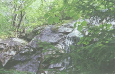
this shape allows it to hold rain water.When the group reached the cascades, their attention turned to eating lunch. We relaxed on dry rocks that the water gracefully skirted around, while continuing its many-stepped fall farther downstream. Despite all the recent rain we've had in our area, the water flow was rather light.
Hemlock and birch stood on the shorelines. After lounging around for a while, part of the group decided to tackle the steep trail that continues up alongside the cascades to find the point where the water begins falling. From this elevated spot, the cascades dropped below us and out in front of us was Flume Peak. Off to the left, we could just barely make out the green swaths of the Waterville Valley ski area on Mount Tecumseh.
|
|
|||||

- From I-93 take the exit for Rt. 49.
- Head east on Rt. 49 for approximately 8 miles (a little more I think).
- The parking area is on the right, marked by a brown hiker sign by the side of the road (just after crossing Drakes Brook).
- Once in the parking lot, there will be signs for Sandwich Mountain Trail, Drakes Brook Trail, and Fletcher's Cascade Trail.
From the parking lot, there are two signs for Drakes Brook Trail. One is a horizontally long sign that is for cross-country skiers; you can ignore this one (I think it hooks back up with the hiking trail after going up the hill and that section is re-routed so skiers won't have to go around the gate). As you pull into the parking lot, Drakes Brook Trail starts in approximately the left-hand lower corner (the north side).
Other Notes
WMNF Recreational Pass
A parking permit is required to park at White Mountain National Forest trailheads and parking areas. You can purchase a WMNF permit from the forest service and other vendors and can also pay-by-the-day using self-service kiosks located in many parking areas.
For more information on parking passes please refer to the White Mountain National Forest website.
Rates:
- $5 per day
- $30 for a year-long pass
- $40 for a year for a household
More Fletcher's Cascade Trail Reports
|
|
|||||
Website by
![]() LeapfrogProgramming.com
LeapfrogProgramming.com
© 1998-2024
![]()
| The information on this site may freely be used for personal purposes but may not be replicated on other websites or publications. If you want to reference some content on this site, please link to us. |
